

|
Overview of all data from Vantage Pro2 located at N60 05' 42" E24 33' 51"
|
|||
| Date at this location | 19.05.09 | Sunrise | 4:34 |
| Time updated | 6:28 | Sunset | 22:04 |
External links:
Finnish Met Office forecast, Foreca forecast
Quick links on this page:
Outside temperature, Outside humidity, Barometric pressure, Wind speed (& Chill), Rainfall, Outside heat index, THSW index, Evapotranspiration, Solar radiation, UV Radiation, Outside dew point, Inside temperature, Inside humidity, Inside dew point & Heat index
| Current outside temperature | 7.6 °C |
|
|
| Today's high | 9.3 °C | at | 0:00 |
| Today's low | 7.4 °C | at | 4:54 |
| Month's high | 17.7 °C | Month's low | -1.0 °C |
| Year's high
(2008 = 27.4 °C on 26.07.08
2007 = 27.6 °C on 09.06.07) |
20.6 °C | Year's low (2008 = -12.8 °C on 16.02.08 2007 -23.6 °C on 07.02.07) | -17.2°C |
| Current outside humidity
Humidity itself simply refers to the amount of water
vapour in the air. However, the amount of water vapour that the air can
contain varies with air temperature and pressure. Relative humidity
takes into account these factors and offers a humidity reading which
reflects the amount of water vapour in the air as a percentage of the
amount the air is capable of holding. Relative humidity, therefore, is
not actually a measure of the amount of water vapour in the air, but a
ratio of the air’s water vapour content to its capacity. When we use the
term humidity in the manual and on the screen, we mean relative
humidity. |
97% |
 |
 |
| Today's high | 97 % | at | 6:24 |
| Today's low | 66 % | at | 0:00 |
| Month's high | 100 % | Month's low | 16 % |
| Year's high | 100 % | Year's low | 16 % |
Barometric pressure mb Back to top
| Current barometer reading
The weight of the air that makes up our atmosphere
exerts a pressure on the surface of the earth. This pressure is known as
atmospheric pressure. Generally, the more air above an area, the higher
the atmospheric pressure, this, in turn, means that atmospheric pressure
changes with altitude. For example, atmospheric pressure is greater at
sea-level than on a mountain top. To compensate for this difference and
facilitate comparison between locations with different altitudes,
atmospheric pressure is generally adjusted to the equivalent sea-level
pressure. This adjusted pressure is known as barometric pressure. In
reality, the Vantage Pro measures atmospheric pressure. When you enter
your location’s altitude in Setup Mode, the Vantage Pro stores the
necessary offset value to consistently translate atmospheric pressure
into barometric pressure.
|
1017.5 mb |
 |
 |
| Today's high | 1018.2 mb | at | 1:29 |
| Today's low | 1017.5 mb | at | 4:59 |
| Month's high | 1027.4 mb | Month's low | 997.9 mb |
| Year's high (2008 = 1051mb on 04/01/08 2007 = 1037.2mb on 23/03/07) | 1033.3 mb | Year's low
(2008 =955.6 on 24/11/08 2007 =967.0 on 18/03/07) |
986.9 mb |
| Wind speed Wind Chill (See below) takes into account how the speed of the wind affects our perception of the air temperature. Our bodies warm the surrounding air molecules by transferring heat from the skin. If there’s no air movement, this insulating layer of warm air molecules stays next to the body and offers some protection from cooler air molecules. However, wind sweeps that comfy warm air surrounding the body away. The faster the wind blows, the faster heat is carried away and the colder you feel. |
0.0 m/s |
  |
 |
| Average wind speed last 10 minutes | 0.0 m/s | Wind direction in degrees | 157 |
| Wind direction sector | SSE | ||
| High wind today | 0.4 m/s | at | 0:25 |
| Month's high | 12.5 m/s | Year's high ((2008 = 17.0 m/s on 18.11.08 @ 22.30 2007 = 17.0 m/s on 01.11.07 @ 4.00am) | 14.8 m/s |
| Month's high (Beaufort scale) | Year's high (Beaufort scale) | ||
| Current wind chill
|
7.6 °C | ||
| Today's low | 7 °C | at | 4:54 | Month's low | -1 °C |
| Year's low | -17 °C |
| Today's rain | 0.0 mm |
 |
 |
| Storm rain | 0.0 mm |
 |
|
| Rain rate | 0.0 mm/hr |
 |
|
| Today's high rain rate | 0.0 mm/hr | at | ---- |
| High monthly rain rate | 20.8 mm/hr | High annual rain rate | 20.8 mm/hr |
| Monthly rain | 16.6 mm |
 |
|
| Total rain (2009)
(2008 = 658 mm) |
59.8 mm |
 |
| Outside heat index
The Heat Index uses temperature and the
relative humidity to determine how hot the air actually “feels.” When
humidity is low, the apparent temperature will be lower than the air
temperature, since perspiration evaporates rapidly to cool the body.
However, when humidity is high (i.e., the air is more saturated with
water vapour) the apparent temperature “feels” higher than the actual air
temperature, because perspiration evaporates more slowly. |
7.6 °C |
 |
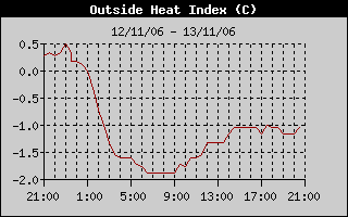 |
| Today's high | 8 °C | at | 0:00 |
| Month's high | 15 °C | ||
| Year's high | 18 °C | ||
Temperature / Humidity / Sun / Wind (THSW) °CBack to top
| High THSW index
The THSW Index uses humidity and temperature like the Heat Index, but
also includes the heating effects of sunshine and the cooling effects of
wind (like Wind chill) to calculate an apparent temperature of what it
“feels” like out in the sun. |
7 °C | at | 0:00 |
| Month's high | 20 °C | ||
| Year's high | 20 °C |
Evapotranspiration (et) mm
Back to top
| Daily et
Evapotranspiration (ET) is a measurement of the amount of water vapour
returned to the air in a given area. It combines the amount of water
vapour returned through evapouration (from wet vegetation surfaces and the
stoma of leaves) with the amount of water vapour returned through
transpiration (exhaling of moisture through plant skin) to arrive at a
total. Effectively, ET is the opposite of rainfall, and it is expressed
in the same units of measure (Inches, millimetres). |
0.0 mm |
| Monthly et | 29.5 mm |
| Yearly et | 29.5 mm |
| Solar radiation What we call “current solar radiation” is technically known as Global Solar Radiation, a measure of the intensity of the sun’s radiation reaching a horizontal surface. This irradiance includes both the direct component from the sun and the reflected component from the rest of the sky. The solar radiation reading gives a measure of the amount of solar radiation hitting the solar radiation sensor at any given time, expressed in Watts /sq. metre (W/m2). |
69 W/m˛ |
 |
||
| Today's high | 79 W/m˛ | at | 5:55 | |
| Month's high | 997 W/m˛ | |||
| Year's high | 997 W/m˛ | |||
| Current UV Energy from the sun reaches the earth as visible, infrared, and ultraviolet (UV) rays. Exposure to UV rays can cause numerous health problems, such as sunburn, skin cancer, skin aging, and cataracts, and can suppress the immune system. The Vantage Pro can help analyze the changing levels of UV radiation and can advise of situations where exposure is particularly unacceptable. |
0.0 index |
 |
||
| High UV | 0.0 index | at | ---- | |
| Month's high | 3.9 | |||
| Year's high | 3.9 |
| Outside dew point
Dew point is the temperature to which air must be cooled for saturation
(100% relative humidity) to occur, providing there is no change in water
vapour content. The dew point is an important measurement used to predict
the formation of dew, frost, and fog. If dew point and temperature are
close together in the late afternoon when the air begins to turn colder,
fog is likely during the night. Dew point is also a good indicator of
the air’s actual water vapour content, unlike relative humidity, which
takes the air’s temperature into account. High dew point indicates high
water vapour content; low dew point indicates low water vapour content. In
addition a high dew point indicates a better chance of rain and severe
thunderstorms. You can also use dew point to predict the minimum
overnight temperature. Provided no new fronts are expected overnight and
the afternoon Relative Humidity ≥ 50%, the afternoon’s dew point gives
you an idea of what minimum temperature to expect overnight, since the
air cannot get colder than the dew point anytime. |
7.2 °C |
 |
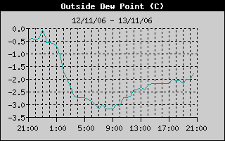 |
| Today's high | 7 °C | at | 5:24 |
| Today's low | 2 °C | at | 0:26 |
| Month's high | 10 °C | Month's low | -11 °C |
| Year's high | 10 °C | Year's low | -20 °C |
| Current Inside temperature | 21.2 °C |
 |
 |
| Today's high | 22.0 °C | at | 0:00 |
| Today's low | 21.1 °C | at | 5:53 |
| Month's high | 27.8 °C | Month's low | 20.1 °C |
| Year's high |
27.8 °C | Year's low | 15.6°C |
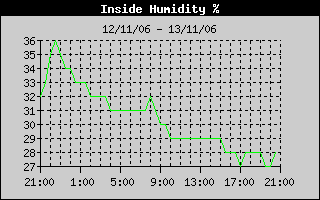
| Current inside humidity | 32% |
 |
|
| Today's high | 32 % | at | 3:48 |
| Today's low | 31 % | at | 0:00 |
| Month's high | 56 % | Month's low | 15 % |
| Year's high | 64 % | Year's low | 11 % |
Inside dew point & heat index °CBack to top
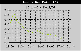
| Inside dew point | 3.8 °C |
 |
|
| Inside heat index | 19.4 °C |
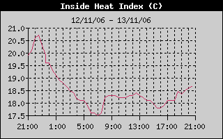 |